Want more images or videos?
Request additional images or videos from the seller.

Johannes Jansson
PERU

c. 1635

$600
£455.60
€546.47
CA$859.30
A$887
CHF 499.96
MX$11,475.72
NOK 5,703.96
SEK 6,017.43
DKK 4,084.53

About the Item

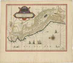
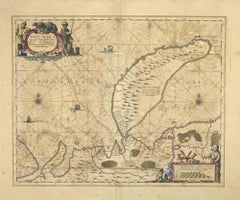
JOHANNES JANSSON (1588 - 1664) PERU, engraving with early coloring. Platemark 15 1/8 x 19 3/8 inches, sheet 17 x 20 1/2 A nice example of one of the earliest maps of Peru. From the Mercater / Hondius Atlas engraved in the lower left Amstelodami Apud Ioannem Ianffonium (Amsterdam the work of Johannes Jansson). Nice cartouche and with sailing ships and whales at the bottom. In generally good condition, the usual centerfold, some slight tone to the paper. Remains of a vertical fold to the right of the centerfold. French text verso. Maps, Americana, South America, Gold, Exploration
  • Creator:
    Johannes Jansson (1729 - 1784, Dutch)
  • Creation Year:
    c. 1635
  • Dimensions:
    Height: 15.125 in (38.42 cm)Width: 19.375 in (49.22 cm)
  • Medium:
  • Movement & Style:
  • Period:
    1630-1639
  • Condition:
  • Gallery Location:
    Santa Monica, CA
  • Reference Number:
    1stDibs: LU41138232782

More From This Seller

View All
AMERICA

AMERICA

By John Speed

Located in Santa Monica, CA

IMPORTANT AMERICAN MAP - ONE OF THE FIRST TO SHOW CALIFORNIA as an ISLAND JOHN SPEED (1552-1629) AMERICA - With Those Known Parts In That Unknown Worlde (sic), 1626-(76) (Burden 217 iv/iv) Engraving, uncolored. Engraved by Abraham Goos and published by Thomas Basset and Richard Chiswell - 4th state of 4 in 1676.15 1/8 x 20 1/2” From “A Prospect of the Most Famous Parts of the World”. Generally good condition. A repaired split in lower centerfold. This is the most common version of this important map...

Category

1620s Old Masters Landscape Prints

Materials

Engraving
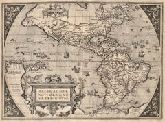
AMERICAE - Sive Novi Orbis, Nova Descriptio

AMERICAE - Sive Novi Orbis, Nova Descriptio

By Abraham Ortelius

Located in Santa Monica, CA

ABRAHAM ORTELIUS (1527 - 1598) AMERICAE SIVE NOVI ORBIS, NOVA DESCRIPTIO, 1587 (1603) (Van Den Broecke 11, Burden 64; Schwartz & Ehrenberg 69) Engraving. A very good, well printed...

Category

16th Century Old Masters Landscape Prints

Materials

Engraving
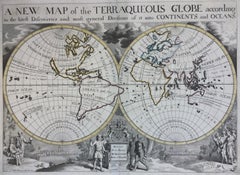
New Map of the Terraqueous Globe - WORLD MAP - CALIFORNIA AS AN ISLAND

New Map of the Terraqueous Globe - WORLD MAP - CALIFORNIA AS AN ISLAND

By Edward Wells

Located in Santa Monica, CA

EDWARD WELLS (British 1667- 1727) A NEW MAP of the TERRAQUEOUS GLOBE - according to the latest Discoveries and most general Divisions of it into CONTINENTS and OCEANS, 1700-01 (Shirley 609) Engraved by Michael Burghers, Oxford. Hand-colored, Platemark 14 1/4 x 20 1/8 inches. Central cartouche flanked by figures representing the continents with dedication to William, Duke of Gloucester...

Category

Early 1700s Old Masters Landscape Prints

Materials

Engraving
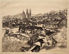
!6th c. VIEW OF FLORENCE

!6th c. VIEW OF FLORENCE

By Sebastian Münster

Located in Santa Monica, CA

SEBASTIAN MUNSTER (1488-1552) FLORENCZ - -- FIGUR UND GELEGENHEIT DER EDLEN UND HOCH BERHÜMPTEN STATT FLORENTZ. . c 1550 (Fauser, #3925.) Woodcut f...

Category

16th Century Old Masters Landscape Prints

Materials

Woodcut

You May Also Like

Blaeu Map of Peru, Antique Hand-Colored Engraving, South America 1642

Blaeu Map of Peru, Antique Hand-Colored Engraving, South America 1642

Located in Langweer, NL

Blaeu Map of Peru, Antique Hand-Colored Engraving, South America 1642 A finely engraved and beautifully hand-colored map of Peru, published by Willem and Joan Blaeu in Amsterdam aro...

Category

Antique Mid-17th Century Dutch Maps

Materials

Paper

Antique Map of Peru by van der Aa, 'circa 1720'

Antique Map of Peru by van der Aa, 'circa 1720'

Located in Langweer, NL

Antique map titled 'Le Perou, Grand Pays de l Amerique Meridionale (..)'. Decorative map of Peru including portions of Ecuador and northern Chile and Boliv...

Category

Antique Early 18th Century Maps

Materials

Paper

Nova Zemla - Etching by Johannes Janssonius - 1650s

Nova Zemla - Etching by Johannes Janssonius - 1650s

By Johannes Janssonius

Located in Roma, IT

Nova Zemla is an ancient map realized in 1650 by Johannes Janssonius (1588-1664). Good conditions. From Atlantis majoris quinta pars, Orbem maritimum [Novus Atlas, volume V: carte ...

Category

1650s Modern Figurative Prints

Materials

Etching

S.Juan de Puerto Rico - Etching by Johannes Janssonius - 1650s

S.Juan de Puerto Rico - Etching by Johannes Janssonius - 1650s

By Johannes Janssonius

Located in Roma, IT

S.Juan de Puerto Rico is an ancient map realized in 1650 by Johannes Janssonius (1588-1664). Good conditions. From Atlantis majoris quinta pars, Orbem maritimum [Novus Atlas, volum...

Category

1650s Modern Figurative Prints

Materials

Etching